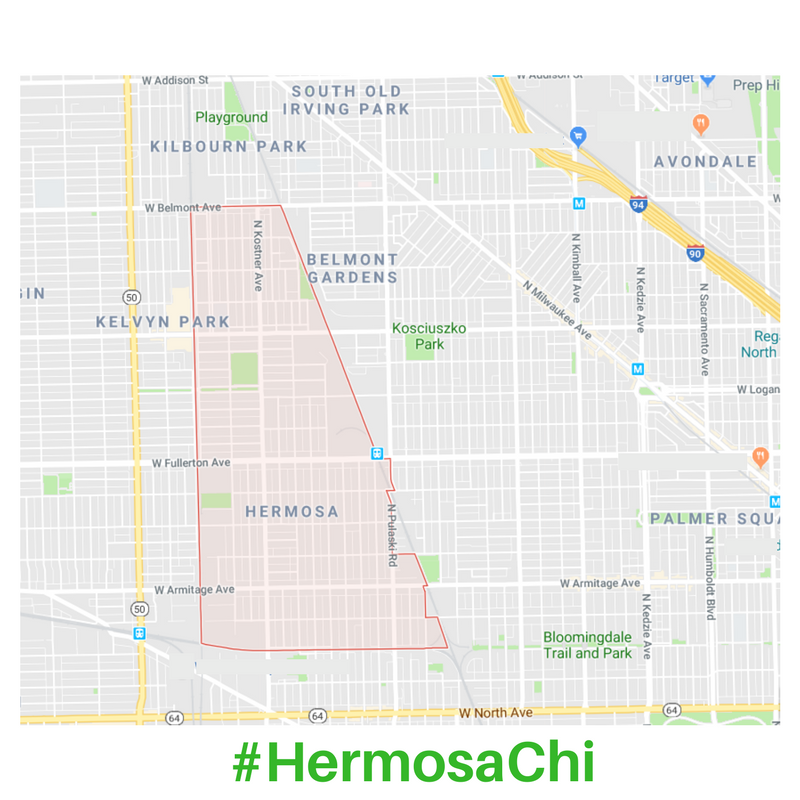
Hermosa, Chicago

Hermosa is most recognizable on the Chicago community map by it's tall, triangle-like shape. Bordered by several Chicago Northwest and West side neighborhoods, Hermosa has ample transportation options and access to many parks, shopping and community services.

From Logan Square to the east, Avondale and Irving Park to the North/Northeast, Belmont-Craigin to the west and Humboldt Park to the south give the neighborhood a centrally-located feel of both city and community.


Interactive map not working for you? 
Check out the map images below.

 
green-bg-1CBA78.png
 

Location + Municipality Facts

Hermosa is #20 out of the official 77 Chicago communities. Community lines are stationary, established by the city in the late 1880’s. Some Hermosa residents call their neighborhood “Hermosa Park” or “Kelvyn Park,” but the city-drawn boundaries never change and are used for census and socioeconomic data through the decades. Here are some other helpful facts:

  • Area Code: 773 (most of Chicago is 773 except for near downtown which is 312)

  • Township: Jefferson (used for property taxes)


Zip Codes

60641
60639
60647

Wards

31st
35th
26th

Police BeaTS

N. of Fullerton: 2521, 2523, 2524
Fullerton to Armitage: 2522, 2525
S. of Armitage Beats: 2533, 2534, 2535

Learn more about your Police Beats + CAPS meetings

 
Screenshot 2018-10-02 17.58.20.png

Transportation Options

CTA Buses
- E/W: 73 Armitage, 74 Fullerton E/W, 76 Diversey E/W, 77 Belmont
- N/S: 53 Pulaski, 54 Cicero

CTA Train
Blue Line. You can catch an Eastbound bus to the Damen, Western, Logan Square or Belmont station.

Metra Train Stations
- Healey Station (Pulaski + Fullerton) - NW
- Grayland Station (Addison + Kostner) - NW
- Grand/Cicero Station - W

Biking
- Divvy Station: Healy Metra Station
- The 606 ends at the Eastern border of Hermosa
- Diversey Ave has bike lanes near Pulaski
- Wrightwood Ave has bike lanes near Kelvyn Park


Hermosa, Chicago Population - 2023*

* Data Source: 2023 Chicago Metropolitan Agency for Planning - Hermosa Community Data Snapshot
 
 
blue-aqua-bg-1CBA78.png
 

Hermosa History


1880s-1899

Hermosa began development after the railroads had expanded through the area, starting in the 1880s. The first settlers were mostly Scottish, German and Swedish immigrants, many skilled workers. One such person was Walt Disney's father, who built a cottage house on Tripp and Palmer in 1893. The first streetcars appeared on Armitage Avenue in 1895, and in 1889, the City of Chicago officially annexed the area. The city-drawn boundaries of the community Hermosa have never changed since this era.

1900-1940

The southern area near Armitage and Fullerton was developed first with workers' cottages, as well as industrial warehouses surrounding the railroad lines. Fullerton Avenue gained streetcar service in 1914, Belmont Avenue in 1917, then Kelvyn Park High School and Kelvyn Park (the Chicago Park District) but it was not until the 1920s that the north end of Hermosa (then marketed as "Belmont Terrace") was developed into residential housing that includes the Chicago Bungalow Belt. In the 1930s, Hermosa’s population grew to near what it is today, around 25,000.


1940-Present

Ken-Well Park was further developed by the city. Industrial manufacturing continued into the 1970s until the economy changed and the US was less reliant on skilled labor.

The population rose and fell, and in the 1980s, the hispanic/latinx residents became the majority, with many nations and dialects represented. Today the neighborhood is still diverse, the housing looks very much the same as it did 100 years ago and new generations are enjoying Hermosa's park and schools as they have during the past century.

In 2018, the Chicago Bungalow Association named the Hermosa Bungalow Historic District to National Register of Historic Places that includes the area north of Diversey.


How does Hermosa compare to nearby Chicago communities in population?